Day 5 was the only other day we set our alarms. Alarms and vacation are two words that just don't go well together. But we didn't want to miss the commuter rail into Boston.

Since we had tried the T, the subway, we thought we would try one of Boston's other mass transportation, the commuter rail. I had seen it on the map I was using, but we met a young mother on the subway on Tuesday who talked about riding it from Kingston all the way to South Station with her daddy when she was little. Kingston was between us and Boston and South Station was where we wanted to go in Boston. Sounded like a winner.
 We got to the station in plenty of time to catch the train that was leaving at 8:37. Not sure we would ever have figured out how to pay for the parking if it hadn't been for a young man who showed us how to stick the 4 dollar bills in the itsy-bitsy slot.
The ride into South Station was so relaxing. I wanted to shut my eyes so badly, but I didn't want to miss anything. Doing all of the driving ( my husband realized at the airport when we were leaving that his driver's license had expired a few days earlier on his birthday), I know I missed out seeing some things. My husband would say I didn't miss anything as he occasionally had to tell me to keep my eyes on the road. I actually noticed things they didn't.
We knew our agenda for the day before we left our cottage...The Freedom Trail and several sites on it. I had a map for one of the trolley companies that I was using as a guide. The only problem was the map didn't include all of the street names (and maybe even streets) so I told Janice to get walking directions from her phone. So this is how she looked as we left South Station heading for The Old South Meeting House.

Friend Fran had told me the Freedom Trail was marked but my trolley car map highlighted the trolley car route not the Freedom Trail. Fran also didn't tell me "how" it was marked, but Siri got us, with a few detours, to our first stop, the Old South Meeting House. We were able to buy our ticket for $13 to get into the Old South Meeting House, Old State House, and Paul Revere's house there.
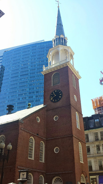 Old South Meeting House was built in 1729 as a Puritan meeting house. Even though they worshiped here, they didn't call it a church as the building was used for many reasons. No photography was allowed inside but it was quite impressive. Colonists met in the building to challenge British rule. "On Dec 16, 1773 more than 5,000 people met here to protest the tax on tea, and heard Samuel Adams give the signal that started the Boston Tea Party. You can read more about Old South Meeting House and see pictures of it HERE.
 Following the map and Siri we headed to our next stop, Old State House. Walking the streets in downtown Boston was so exciting. I couldn't resist taking a picture of what we saw when we looked down one closed street. Janice and Leon said it reminded them of London. Boston has a lot of one-way streets because the streets are so narrow. Many are brick also.
 Before we knew it though we were at Old State House. We got there 15 minutes before the next guided tour was going to start. We weren't allowed to take pictures inside it either. They have three different guided tours beginning at different times. We took the one inside. There was another one that took place outside and told about the Boston Massacre.
 Behind the building the site where on March 5, 1770, the confrontation between colonists and British soldiers that became known as the Boston Massacre occurred. You can see inside pictures and read more about Old State House and the Boston Massacre HERE.
Here is one more view of the building from across the street.

 While trying to find Faneuil Hall using my trolley map, a worker at a construction site nearby, heard me talking and stopped (without my asking) and started telling me how to get there. He also said the trail was marked and I couldn't miss it. It was at this point, I noticed how the trail was marked.
Talk about feeling dumb. The reason we hadn't noticed it though was because we were looking up at street signs not down at the sidewalk. Later my husband said he had noticed it and didn't realize we hadn't. I do want to say to repeat that South Station isn't on the "trail" and we didn't run into the marked sidewalk trail until we got to Old South Meeting House and Fran didn't tell me how it was marked. I was looking for signs marking the trail.
 Faneuil Hall and
 Quincy Market behind is where all the people were.
THIS is an excellent link to all of the places we visited and many we didn't have time to see. I would really recommend that you check it out if you are interested in more information and pictures than I can show here.
Now that we knew how the trail was marked, we looked down more than up. When I saw this marker on the trail, I stopped everyone so I could get a picture of it. I thought it was there to mark the trail

 Before too long, we came up on a statue of Paul Revere. The wall identified the place as Paul Revere's Mall. I could see the church down the way and realized it had to be the Old North Church. That meant we had missed Paul Revere's House. How could we have done that? I told everyone that we would find it when we backtracked our steps.
Old North Church wasn't one of the museums we had paid to see on the Freedom Trail. The church is still used and they had a container for contributions. They did allow pictures inside and I took a number. It was beautiful!

 This poster in Robert Newman's family pew discusses that he might have been one of the two men who hung the two lanterns in the church on the night of April 18, 1775 to warn the colonists re the British soldiers.
If you want to read more.
 Retracing our steps to find Paul Revere's House, I discovered why we had missed it. Remember this picture?
Well, it wasn't marking the trail, it was marking a historic site...Paul Revere's House. It's not good to always look down. ha. We toured the house but I forgot to take a picture of it on the outside. You can see what it looks like HERE.
Janice and I had planned to walk to the Boston Common and to the State House and Granary Burying Grounds, but Leon wanted to see where the Boston Tea Party had taken place. It was going to be impossible to see all of it. Janice and I said we would just have to plan another vacation and come back and see what we had missed. So we headed to the wharf using my trolley map to see where the Boston Tea Party happened. This is not part of the Freedom Trail.

We decided not to pay the admission fee of $25+/a person that it was going to cost us and walked back to South Station to catch the commuter rail back to Kingston. We had to wait a while (30 to 45 minutes, I think) for our train, but we found a table and it was good to sit down after all of our walking.
Back in Mashpee, we ate dinner at a Ninety Nine Restaurant since we had enjoyed our meal so much on Tuesday. We didn't play canasta that night as it was later when we got home. We had seen so much history that day and only had one more full day to see the rest of the Cape.
If you missed the beginning of our trip, you can go HERE. There is a link at the end of each post for the next day. You can go HERE to read the final post for our vacation.

Since we had tried the T, the subway, we thought we would try one of Boston's other mass transportation, the commuter rail. I had seen it on the map I was using, but we met a young mother on the subway on Tuesday who talked about riding it from Kingston all the way to South Station with her daddy when she was little. Kingston was between us and Boston and South Station was where we wanted to go in Boston. Sounded like a winner.

The ride into South Station was so relaxing. I wanted to shut my eyes so badly, but I didn't want to miss anything. Doing all of the driving ( my husband realized at the airport when we were leaving that his driver's license had expired a few days earlier on his birthday), I know I missed out seeing some things. My husband would say I didn't miss anything as he occasionally had to tell me to keep my eyes on the road. I actually noticed things they didn't.
We knew our agenda for the day before we left our cottage...The Freedom Trail and several sites on it. I had a map for one of the trolley companies that I was using as a guide. The only problem was the map didn't include all of the street names (and maybe even streets) so I told Janice to get walking directions from her phone. So this is how she looked as we left South Station heading for The Old South Meeting House.


Here is one more view of the building from across the street.


Talk about feeling dumb. The reason we hadn't noticed it though was because we were looking up at street signs not down at the sidewalk. Later my husband said he had noticed it and didn't realize we hadn't. I do want to say to repeat that South Station isn't on the "trail" and we didn't run into the marked sidewalk trail until we got to Old South Meeting House and Fran didn't tell me how it was marked. I was looking for signs marking the trail.


THIS is an excellent link to all of the places we visited and many we didn't have time to see. I would really recommend that you check it out if you are interested in more information and pictures than I can show here.
Now that we knew how the trail was marked, we looked down more than up. When I saw this marker on the trail, I stopped everyone so I could get a picture of it. I thought it was there to mark the trail


Old North Church wasn't one of the museums we had paid to see on the Freedom Trail. The church is still used and they had a container for contributions. They did allow pictures inside and I took a number. It was beautiful!

 |
| The organ |
 |
| A plaque on the wall recognizing that Rev. Charles Wesley, John Wesley's brother, had preached twice there in 1736. |

If you want to read more.

Well, it wasn't marking the trail, it was marking a historic site...Paul Revere's House. It's not good to always look down. ha. We toured the house but I forgot to take a picture of it on the outside. You can see what it looks like HERE.
Janice and I had planned to walk to the Boston Common and to the State House and Granary Burying Grounds, but Leon wanted to see where the Boston Tea Party had taken place. It was going to be impossible to see all of it. Janice and I said we would just have to plan another vacation and come back and see what we had missed. So we headed to the wharf using my trolley map to see where the Boston Tea Party happened. This is not part of the Freedom Trail.

We decided not to pay the admission fee of $25+/a person that it was going to cost us and walked back to South Station to catch the commuter rail back to Kingston. We had to wait a while (30 to 45 minutes, I think) for our train, but we found a table and it was good to sit down after all of our walking.
Back in Mashpee, we ate dinner at a Ninety Nine Restaurant since we had enjoyed our meal so much on Tuesday. We didn't play canasta that night as it was later when we got home. We had seen so much history that day and only had one more full day to see the rest of the Cape.
If you missed the beginning of our trip, you can go HERE. There is a link at the end of each post for the next day. You can go HERE to read the final post for our vacation.
No comments:
Post a Comment